
Inland Navigation
Recommended speed limits for the Flemish Waterways
The regulations with respect to the maximum allowed speed of inland vessels in the waterway network in Flanders are not always adapted to the present fleet and waterway dimensions. Researchers associated with the Knowledge Centre were requested by the two waterway authorities that are merging into De Vlaamse Waterweg nv to formulate recommended speed limits for several ship types and loading conditions for the Flemish waterways, comprising more than 850 km length in total
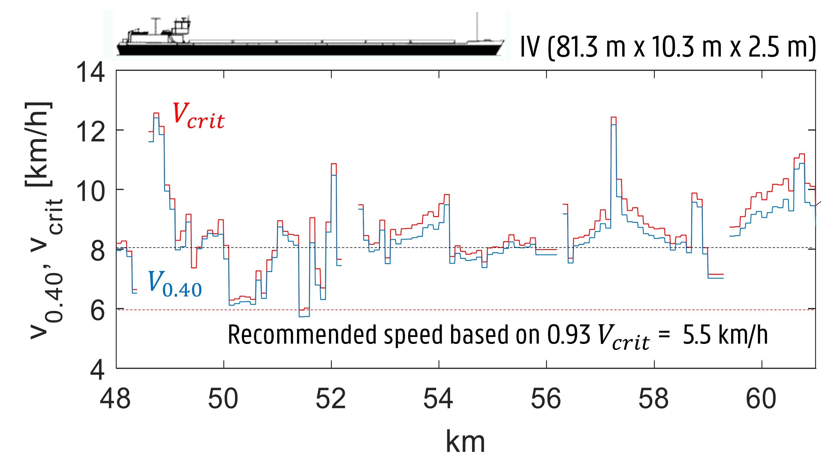
A methodology had been developed to recommend speed limits for the Albert Canal, as mentioned in our 18th newsletter. Three speeds are determined. A first speed lies close to the critical speed to avoid excessive fuel consumption. A second speed is the speed at which the wave height at the bank reaches a limit value of 0.40 m, which was determined following a methodology given in Bulletin No. 88 of the German Federal Waterways Engineering and Research Institute.
A third speed was determined in case a ship passes a moored vessel. The forces on the mooring lines will approximately increase with the passing speed squared. There are no general guidelines to which value these forces should be restricted and the choice was made to determine the speed for which the force on a moored ship reaches 20% of the breaking strength of a mooring line. This maximum passing speed could be determined using the dedicated software package ROPES for different vessels . The recommended speed for a particular vessel at a given point in a waterway is then the minimum of the three speeds that have been determined.
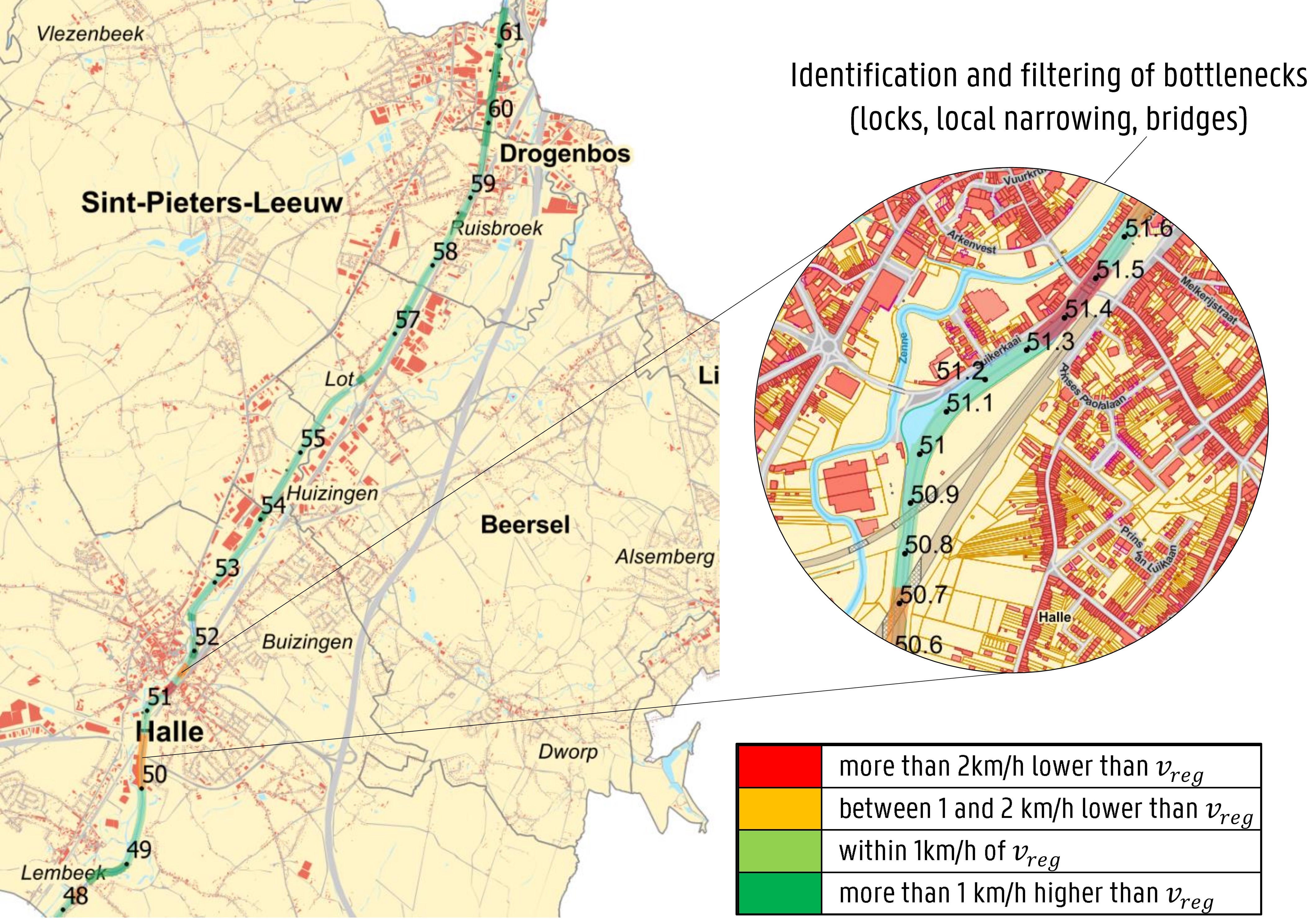
One of the major parameters that influences these speeds is the blockage factor, which is the ratio of the cross-sectional area of the vessel to the cross-sectional area of the waterway. Special tools were developed so that cross-sectional areas along a waterway can be determined and visualized from bathymetric survey data. For each waterway, the recommended speeds were then determined for typically two types of vessels at two different loading conditions. In order to simplify the regulations, the ship types and dimensions were then grouped into categories. If considered appropriate, a waterway could be divided into different sections, each with a separate set of recommended speeds. The results can be visualized with GIS mapping tools.
The proposed recommended speeds were then discussed with stakeholders of the inland navigation community in order to arrive at speeds that are generally acceptable and practically implementable. The final recommended speeds will be implemented in 2018 and it is the objective that they can also be consulted on VisuRIS, the online waterway information platform.
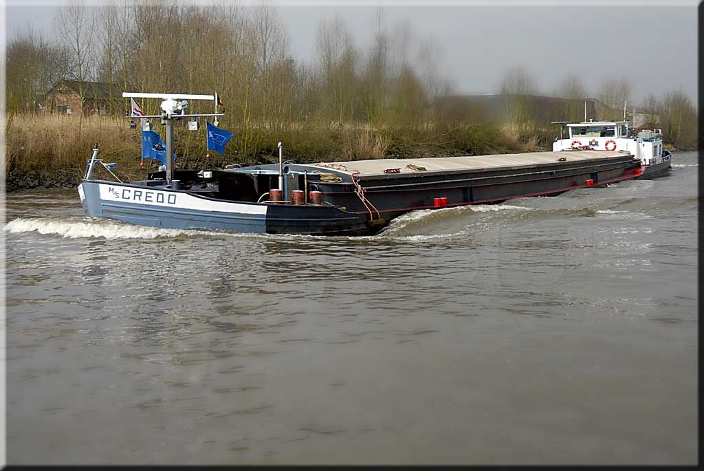
Research into push barge convoys
Push barge convoys have a reputation to be less manoeuvrable than conventional inland ships. The very low displacement and high wind areas of the empty barges or the large tonnage and long lengths of fully loaded combinations are some of the factors decreasing its manoeuvrability. As a result, the required path widths and turning circles are large.
In 2010 Flanders Hydraulics Research received several questions to investigate the measures that have to be taken in order to allow push barge convoys in some narrow waterways. To further validate the simulator models that are applied in these studies both onboard measurements and towing tank experiments have been carried out.
Full-scale measurements of the motions in six degrees of freedom were carried out on the pusher Lianco for different configurations and different loading conditions of the barges. The model tests were carried out at 1:25 scale, resulting in a total model length of 7.4 metre. During the tests both the forces on the complete convoy and the forces and moment in the horizontal plane of the pusher acting on the barges were recorded. In the coming months, the full-scale measurements as well as the model scale results will be further analysed.
Accessibility studies for inland vessels
Flemish inland waterways are part of the European network for inland transport but their capacities are under investigation. Not all waterways are accessible for the larger class Va and class Vb vessels. Instead of performing a potentially risky full-scale trial with the desired CEMT class in an existing channel or river, simulations on inland simulators can help in defining the capabilities for both ship and waterway.
In September 2010 a new inland simulator was installed at Flanders Hydraulics Research especially designed for research and development. The mathematical models for the manoeuvring behavior of the class IV (85 m x 9.5 m) and Va (110 m x 11.4 m) vessels in open water have been implemented and additional external effects such as bank effects and ship-ship interaction have been modeled. Validation was based on trial voyages with inland vessels on for example the Upper Sea Scheldt, which is now accessible for class IV inland vessels from the Durme estuary to the locks in Merelbeke. The Upper Sea Scheldt is a tidal river characterized by many bends with bend radii which are often smaller than the values recommended by national and international guidelines for inland waterways. Very shallow zones restrict the channel width so that loaded class IV vessels can only sail the river at high tide.
To examine all possible bottlenecks, such as narrow areas, touching the bottom, the passage of bridges and quays and encountering other ships, real-time simulations can help in evaluating the priorities to modify the existing waterway. Studies for both national and international companies are under investigation or are being prepared. These studies show the importance of constant improvements to the simulation models for inland vessels.
Manoeuvring behaviour of inland navigation vessels
Extensive model testing has been carried out to provide data which can be used to evaluate simulations of the manoeuvring behaviour of inland navigation vessels. A mathematical model has been developed to predict the behaviour of a vessel of class Va. This model has also been scaled to predict the behaviour of class IV vessels. Fast-time model testing with both vessel types has been carried out for two different loading conditions, whereby interpolated conditions in both draft and under keel clearance have been studied. These results will be used to evaluate the manoeuvring behaviour in restricted areas and rivers with real-time simulations.
This project complements the development of two purpose-built simulators for inland navigation. Both the in-house simulator as the simulator which was developed for LENA are now in use for educational and research purposes.
Estuary Navigation
Estuary ships are basically inland waterways vessels strengthened and equipped to the extent that they can safely operate in the coastal waters between e.g. the West Scheldt estuary and the port of Zeebrugge when weather conditions are favourable.
In the past the weather window was limited to sea states with significant wave heights up to 1.2 m. New rules allow operation in higher sea states, provided that the ship-owner presents a risk assessment study showing that the design of his ship meets all requirements in all sea states up to the proposed limiting seaway. As the new regulations are aimed at avoiding excessive ship motions, shipping of green water and wave impact loading, the risk analysis for the design of these ships can be based on well-proven linear strip theory calculations for the determination of wave loads and ship motions. Accordingly, a risk analysis procedure has been developed which is now being used for the actual design of such ships.